Snow and wind warnings issued by Met Office as region faces cold snap


While Scotland and the north can expect snowfall on higher ground much of the UK will again be battered by gale force winds similar to those experienced during Storm Barney earlier this week.
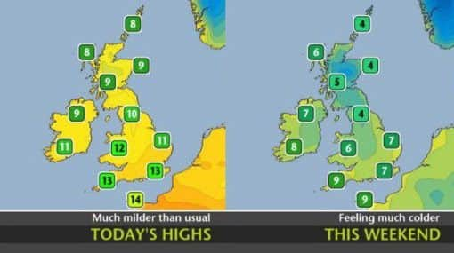
Strong to gale force north or northwesterly winds are also likely Friday night and Saturday across much of Britain and will enhance the cold feel in what will be the coldest air of the season so far. There is a risk of severe gales with gusts of 60-70mph in the most exposed locations.
Advertisement
Hide AdAdvertisement
Hide AdYellow ‘be aware’ National Severe Weather Warnings have been issued for the risk of impacts as a result of the snow and wind.
Chief Operational Meteorlogist Frank Saunders said: “With strong winds and some snow forecast for this weekend there is the likelihood of some difficult driving conditions and disruption to transport. There remains some uncertainty regarding the strength of the wind and snow amounts and so if you have travel plans over the weekend we’d advise that you keep an eye on the warnings for your area.”
This cold spell will be fairly short-lived with temperatures expected to return to more typical values for the time of year early next week with the weather remaining unsettled.
The following is the Met Office’s full forecast for the east this weekend.
Advertisement
Hide AdAdvertisement
Hide AdToday: Thicker cloud may bring a little rain to the far south of the region for a time this morning, otherwise some sunny spells by midday, and just the odd shower developing in the afternoon. becoming windy by evening. Maximum Temperature 9°C.
Tonight: Showers dying out for a time, but more general showery rain developing by morning, heavy at times, and with a wintry mix in places. Winds becoming strong to gale force. Minimum Temperature 0°C.
Saturday: Sunny spells and occasional wintry showers, these tending to become confined to East Anglia during the afternoon. Strong to gale force northerly winds moderating later but still feeling bitterly cold. Maximum Temperature 6°C.
Outlook for Sunday to Tuesday:
Cold with further wintry showers on Sunday. A frosty start on Monday then bright or sunny intervals and a few showers. Milder on Tuesday with rain spreading east.